The Chornobyl Wildfire Danger Portal
This prototype web portal displays real time ignition prediction maps for the Chornobyl exclusion zone based on historical ignition patterns and fire weather forecasts. Geospatial data describing potential fire behavior, radionuclide exposure, suppression resources, and other factors related to overall fire danger can also be viewed and overlayed on the ignition predictions. These data can be queried after a reported ignition using a point-click to generate a summary of the data. This work is the result of a long-term collaboration between the USDA Forest Service and Ukrainian scientists and is supported by the Forest Service International Programs East Europe program.
To access the map portal log in and click on the "View Map" link. Note: Access to the site requires a username and password – please contact Rich Lasko at rich.lasko920@gmail.com
Background
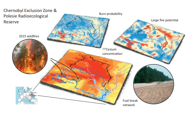
The current fire danger models used in fire prone regions of Ukraine and elsewhere generally do not incorporate predictions of human initiated ignitions, specifically the spatiotemporal patterns that arise from land use, arson and other human activities. The exclusion of space-time human ignition patterns is typical for fire danger indices that are based only on weather and are a significant deficiency in predictive capability for pre suppression planning and active response in human dominated fire systems. Development and implementation of a robust fire danger index and supporting predictive ignition and fire behavior models for Chornobyl, where suppression response needs to be carefully considered in light of radionuclide contamination levels, could substantially improve the effectiveness of current wildfire prevention and management. Furthermore, the Chornobyl system could be used as a template to create similar systems in other regions and countries.
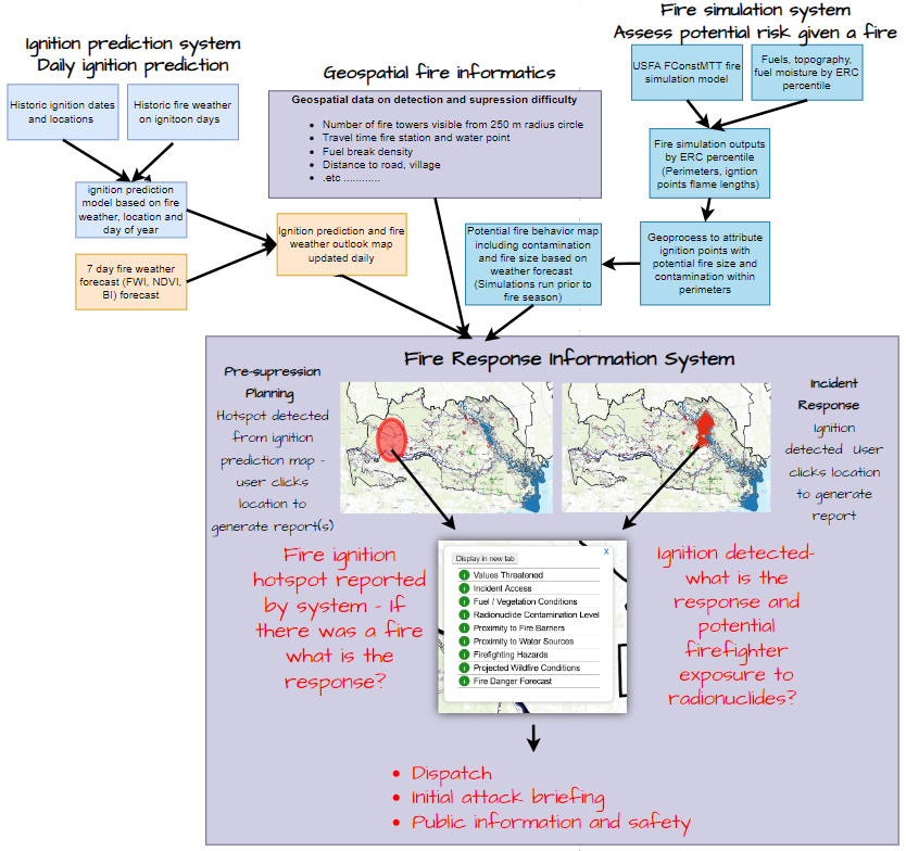
The core of the model uses three open source and established models for connecting ignition prediction with real time weather forecast to map fire danger, and connects these predictions with fire simulation modelling to estimate predicted suppression difficulty and potential radionuclide contamination within predicted fire perimeters. Combining these systems with spatial information on values at risk (social, economic, and natural resource) creates a powerful information system that can be used for both long term suppression planning as well as live response planning when an ignition has been detected within the Chornobyl exclusion zone.
In strategic application, fire predictions are combined with spatial information on suppression difficulty (e.g., distance to road), potential fire spread from simulation models, values at risk, and radionuclide contamination levels to identify hotspots of likely ignitions and develop long-term response strategies. This functionality supports pre-suppression planning (e.g., prioritizing new fuel breaks, positioning wildfire suppression resources, and targeting fire prevention activities), as well as developing “what if” scenarios based on predicted hotspots for fire management scenario planning.
In turn, these model outputs are combined with spatial information on suppression capacity, transportation networks, fuel breaks, values at risk, and fire behavior characteristics, to provide managers with information to prioritize suppression response for multiple incidents. This information also provides firefighters with a tactical scorecard of relevant information for safely suppressing detected wildfire incidents.
This system can be used to 1) allocate suppression resources to specific locations during the fire season and multiple fire scenarios; 2) prioritize fuel breaks and target prevention activities to locations that have high predicted ignition rates; and 3) safely respond to active incidents with the appropriate precautions based on predictions of radionuclide exposure. Longer term strategic planning can be done by comparing the forecast and obtaining information generated from fire simulation outputs.
Publications
- Ager, Alan A.; Lasko, Richard; Myroniuk, Viktor; Zibtsev, Sergiy; Day, Michelle A.; Usenia, Uladzimir; Bogomolov, Vadym; Kovalets, Ivan; Evers, Cody R. 2019. The wildfire problem in areas contaminated by the Chernobyl disaster. Science of the Total Environment. 696: Article 133954.
- Ager, A. A., M. A. Finney, R. J. Lasko, and C. Evers. 2015. Probabilistic wildfire and fuels risk assessment for the Chernobyl Exclusion Zone. Internal Report, USDA Forest Service, Washington, D.C.
- Ager, A. A., V. Myroniuk, S. Zibtsev, U. Usenia, V. Bogomolov, I. V. Kovalets, and M. A. Day. 2021. Wildfire danger forecasting for the Chernobyl region. Pages 292-296 in International Science and Applied Conference: Materials Handbook I Ministry of Environmental Protection and Natural Resources of Ukraine State Agency of Ukraine on Exclusion Zone Management Chornobyl Radiation and Ecological Biosphere Reserve, Polissia National University (UNEP-GEF).
- Lasko, R. J., A. A. Ager, and M. A. Day. 2021. Planning and collaboration to meet the wildfire challenge in the Chernobyl Exclusion Zone. Pages 305-309 in International Science and Applied Conference: Materials Handbook I Ministry of Environmental Protection and Natural Resources of Ukraine State Agency of Ukraine on Exclusion Zone Management Chornobyl Radiation and Ecological Biosphere Reserve, Polissia National University (UNEP-GEF).
- Lasko, R. J., A. A. Ager, and S. Slemp. 2020. Forest Service assistance to Ukraine following the Chernobyl disaster. Fire Management Today 78:5-10.
Collaborators
- Alan A. Ager, USDA Forest Service, Missoula Fire Sciences Laboratory, Rocky Mountain Research Station (Emeritus Scientist)
- Viktor Myroniuk, National University of Life and Environmental Sciences of Ukraine
- Haiganoush Preisler, USDA Forest Service, Pacific Southwest Research Station (retired)
- Matt Jolly, USDA Forest Service, Missoula Fire Sciences Laboratory, Rocky Mountain Research Station
- Richard Lasko, USDA Forest Service, National Headquarters, Fire and Aviation (retired)
- Ken Bunzel, Kingbird Software, LLC
- Oleksandr Borsuk, Science Department Chornobyl Radiation and Ecological Biosphere Reserve
- Serhii Sydorenko, Ukrainian Research Institute of Forestry and Forest Melioration named after G. М. Vysotsky
- Matt Wills, USDA Forest Service International Programs
- Petro Pavlychenko, USDA Forest Service International Programs
Acknowledgments
This work was funded by the USDA Forest Service International Programs. We thank Matt Wills and Shelia Slemp from the Forest Service International Programs, for past and continued support of the wildfire management and research mission in Ukraine.