What is SoCal EcoServe?
EcoServe is a tool to visualize and quantify ecosystem services and the impacts of wildfire on services in southern California.
Data on six ecosystem services: water runoff, groundwater recharge, carbon storage, sediment export, recreation,
and biodiversity have been modeled and compiled for a study area encompassing the Angeles, Cleveland, Los Padres,
and San Bernardino national forests in southern California, totaling 3,515,805 ha (8,687,731 acres)
(see Underwood et al. 2018).
Intended users
EcoServe provides a transparent and repeatable framework for USFS resource managers and partners
in southern California to assess the impacts of wildfire on ecosystem services; to help prioritize areas
for post-fire restoration, and provide data to assist with environmental resource damage assessments.
Using SoCal EcoServe
The web mapping tool can be accessed using a link from the homepage, no software installation is required.
Most users will interact with the tool using the web mapping tool accessed under the
Open SoCal EcoServe link on the heading above.
To date, EcoServe includes wildfires that have occurred on the Angeles, Cleveland, Los Padres,
and San Bernardino national forests from the last 15 years (2014-2019),
as well as selected large fires from 2003, 2007, 2009, 2012, and 2013. For a selected wildfire,
EcoServe displays maps of the pre- and post-fire ecosystem services data; tables and graphs
summarizing the quantity of services; and the ability to download the data.
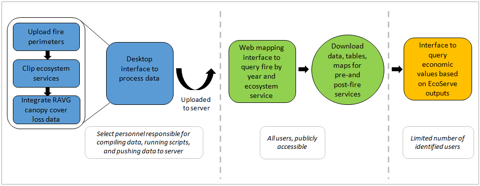
EcoServe is supported by a desktop tool where wildfire and ecosystem services data for new fires can be processed, and uploaded to a public server for use in the web mapping tool. The desktop tool can be accessed by specialist users if additional fires need to be processed. A final component of the tool takes the outputs of SoCal EcoServe for water runoff, groundwater recharge, sediment erosion, and carbon storage and applies monetized and economic values to help inform estimates of the environmental damages of wildfire.

Funding for SoCal EcoServe
Funding was provided by the USDA Forest Service Pacific Southwest Region, the USDA Forest Service’s Western Wildland Environmental Threat Assessment Center (WWETAC), the California Landscape Conservation Partnership (formerly the California Landscape Conservation Cooperative), and the California Department of Forestry and Fire Protection (CalFire), and the University of California, Davis.
References
Underwood, E.C., A.D. Hollander, P.R. Huber, and C. Schrader-Patton. 2018. Mapping the value of national forest landscapes for ecosystem service provision. Pages 245-270 in Underwood, E.C, H.D. Safford, N.A. Molinari, and J.E. Keeley, editors. Valuing chaparral: ecological, socio-economic, and management perspectives. Springer Series on Environmental Management. Springer, Cham, Switzerland.
If you have any questions about the EcoServe tool please contact: charlie.schrader@usda.gov


